
-
5.0 Stars ⭐⭐⭐⭐⭐ 628 Google Reviews


Frederic
-
Posts
9,048 -
Joined
-
Last visited
-
Days Won
455 -
Country
Belgium -
Carnity Points
4,017 [ Donate ]
Content Type
Profiles
Forums
Advice
Business Listing
Car Deals
Recall
OBD II Car Diagnostics
Guest lead capture
STORE
Events
Gallery
Blogs
Everything posted by Frederic
-
 Thanks for informing, we’ve heard that from some members. Take care and see you next week !
 -
Hi @Roopesh babu as you are an Absolute Newbie you will need to join an Absolute Newbie drive first. You were signed up on that one this morning but did not show up.
-
DRIVE REPORT Absolute Newbie drive with Absolute Perfect Team ! Seeing all these new faces is an amazing thing. Seeing their smiles after the drive is even better ! @Alexander Alcala brought his mighty Black Rubicon straight from Chile, and it was clear he has gone offroad before. You did an amazing second lead, and thanks for your patience and good communication throughout the drive. Love to see you coming back for more ! @Haarun Baig was just like most of the convoy putting his first steps in the sand, and i fully understand that it can feel a bit scary at first, but soon you'll be gliding that Pajero through the dunes like it's nothing. Throughout your few refusals you remained calm and followed the instructions precisely. Well done! @SyedObaid Your Pajero was having fun and i hope you and your passenger had fun too ! You used the diff lock a few times during the self recovery and were always able to get yourself out of the situation ! @jose Shanu drove with a smile the whole morning that could be seen from far away, you controlled your Prado very well and i hope your perception about offroading is positive and i agree offroading is an absolute confidence builder. @Malachy McGrogan with the mighty F-150 drove like he was on a picnic. Never stressed, no struggled, and just the right amount of power at the exact right time. Very impressed ! @Shyam Karat with the red beast is finding his way in this terrain, and soon you will unleash the full power after every drive. Well done ! @Piotr Kolodziej your enthusiasm is second to none, i loved your attitude from the start, willingness to learn, and the smile on your face after that amazing self recovery that took some time, patience, and restraint. You drove really well and would love to see that enthusiasm again the next weeks ! @Abdallah Rachidi Alaoui your Wrangler had a bit of a mind of its own, but you completely unleashed her once you found the right gears. Very well done ! @PN1207 was put at the back of the convoy in front of my trusty sweep @Brette, so they could share some hints/tricks about the WK2. You did really well today ! I want to thank all of you for the patience while dealing with the refusals. As i mentioned this is a teamsport and we all go out together and look after each other. @Brette was as always superb in his sweeping duties and the perfect support on my drive. Moving forward you all will be joining the Newbie drives and not an Absolute Newbie drive. Drives are announced every Sunday at 11 am, and they go live on Sunday at 7 pm. Due to the high demand, these drives get full in about 10 minutes, so please be online at 7 pm to book your spot. For the next drives, please bring along a deflator, pressure gauge, flag and radio as a minimum. Learn to deflate your tires and checking them precisely Learn to fix a flag on your car Learn to program and fully charge your radio Also like I mentioned during the debriefing, join the Carnity Whatsapp Drive Notification to get the latest updates on the drives, so that you can RSVP on time for the next weekend's drive. Please have a look at below topic which describes the tools needed for every level: Please have a look at below grading structure that explains various off-road levels: See you next weekend on the sand. Till then take care and drive safe. Did not attend the drive: @Farook Veettil @Krishnakumar @Roopesh babu
-
That is perfect @PN1207 ! See you tomorrow!
-
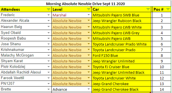
RSVP IS NOW CLOSED @Shyam Karat @Piotr Kolodziej @Krishnakumar @Alexander Alcala @Haarun Baig @Abdallah Rachidi Alaoui @Malachy McGrogan @SyedObaid @jose Shanu @PN1207 @Farook Veettil @Roopesh babu Thanks for signing up for your first official Carnity drive ! Below you can find your convoy positions for tomorrow. Myself and @Brette who's an experienced offroader in our club, will do our best to make your first steps in the desert sand enjoyable and fun ! The plan is to meet up at 5:00AM at the pinpoint location in Al Qudra (see drive post). We will start with deflating our tyres to approx 13-15psi so instead of digging into the sand, we can float over it. This is the common thing we always do before entering the dunes. Deflating can take a but of time if you have not done before, so kindly arrive a bit earlier in that case so we can help you out. After a quick briefing, which will be a slighly shorter version of the briefing video (MUST WATCH), we will head out to the dunes and start practicing. The drive will be around 3hrs and we will try to cover around 20-25kms before heading back to the point where we left off. From there you can re-inflate your tyres if you have a compressor, or drive to the nearest petrol station to inflate which is only 5mins away. For your first drive, a pressure gauge and/or tyre deflator tool is sufficient. From the second drive onwards, an offroad flag, compressor, radio, and shovel will become your basic offroad gear. Some interesting tutorials below: The Absolute Newbie Briefing Video contains ALL the basic info to prepare yourself for this new exciting hobby. Take your time to go through it, and please take note of the COVID19 precautions we have in place that allows us to continue organizing these drives safely and in line with government regulations. For emergency cases, you can contact me on 056 504 2632 Front AND Rear towpoints are a MUST, so please check and double check to see if you have them. Otherwise we cannot allow you for the drive as it would not enable us to recover you safely during a stuck. See you guys tomorrow !
-
Sertac has been promoted to Advance level
Frederic replied to Gaurav's topic in Off-Road Club's Announcements
Congrats @sertac ! Well deserved promotion ! -
Hi @PN1207 Please do verify as some Jeep Grand Cherokee does not come standard with rear recovery point. Without a proper rear recovery point we can not allow you on the drive.
-
Gaia GPS For Beginners - 2024 Update
Frederic replied to Frederic's topic in Off-Road Club's Discussions
@Chaitanya D your request is not naive at all, and we have been thinking about setting up a kind of workshop to do this. Ideally there are two parts to cover: - Using the GaiaGPS website (can be maybe done over ZOOM/Skype). - Using the GaiaGPS Mobile App (should be done on the terrain). To start off, i would recommend that you register and try the free Gaia app for a while to see if the functionality and buttons are intuitive as per your liking. You can already record your coming weekend's drive and experiment a bit. Once you become comfortable you can go for the paid membership account which will open a lot more doors (and maps). We can keep using this thread to discuss. -
Hi @PN1207 Welcome to Carnity Offroad Club ! Kindly introduce yourself and provide the following: 1) Which 4x4 are you driving ? 2) Any prior offroading experience ? 3) Is your vehicle equipped with front and rear towpoints ? Are they in perfect condition ? Please take your time to go through the Newbie Briefing video so you will enjoy your drive tomorrow by being prepared.
-
Gaia GPS For Beginners - 2024 Update
Frederic replied to Frederic's topic in Off-Road Club's Discussions
@Ale Vallecchi and @Srikumar are using Mytrails. I think it's a very good alternative if you are on Android platform. I think it has no IOS app. Have not used it before, but as with most things every program will come with its own strengths and flaws. I chose for GaiaGPS because of the massive userbase for hiking and overlanding in US, which makes the software coming with regular updates and improvements and hope it will stay around long enough. Also the website functionality where i can sit at home and use the website to manage and create routes. Much easier than fiddling on a tiny mobile screen. MotionX is also really good for IOS, but is now fading our their functionalities and looks a bit dated. -
Gaia GPS For Beginners - 2024 Update
Frederic replied to Frederic's topic in Off-Road Club's Discussions
Go for 60inch. You know what they say.... go big or go home For preparing your tracks/routes which you can do from the comfort of your couch or office, layering the topo and satellite is a really good idea. I normally create a "test" route just from looking at the terrain and the total distance i'd like to cover. For Absolute Newbies and Newbies we generally cover around 20-25 kms. Fewbie level and up this easily goes to 40 up to 70 and more, depending on the number of sabkhas where you can drive in 5th gear. @Ale Vallecchi is probably record holder in this. -
Hi @Sreejith Sreenivasan The Absolute Newbie drive is solely for first-time joiners in the club, and unfortunately not for regular members.
-
Mohamed Seidam has been promoted to fewbie level
Frederic replied to Gaurav's topic in Off-Road Club's Announcements
@Mohamed Seidam Congrats ! -
AviG has been promoted to fewbie level
Frederic replied to Gaurav's topic in Off-Road Club's Announcements
Congrats @AviG ! -
Gaia GPS For Beginners - 2024 Update
Frederic replied to Frederic's topic in Off-Road Club's Discussions
So the Super premium version maybe will ride the dunes for us ? 😅 -
Gaia GPS For Beginners - 2024 Update
Frederic replied to Frederic's topic in Off-Road Club's Discussions
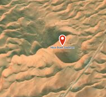
Difference between Topo map and Sattelite Image: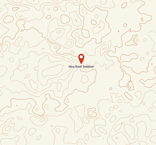
-
Gaia GPS For Beginners - 2024 Update
Frederic replied to Frederic's topic in Off-Road Club's Discussions
Topo maps needs some practice to read, and i have been fooled a few times by them (Won't get foooooled again !!). I have the following overlays enabled. Every once in a while i enable "public tracks" to see if anyone has posted or made tracks in the area i am scouting. In the Premium version you can also overlay 2 maps on top of each other @Wrangeld has used this functionality before. I did not try that yet.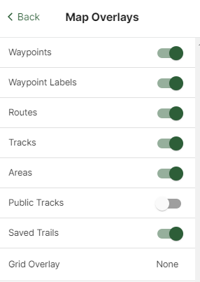
-
Gaia GPS For Beginners - 2024 Update
Frederic replied to Frederic's topic in Off-Road Club's Discussions
Brillant ! I mostly use waypoints to identify play areas, and use the "create area" functionality to draw a rectangular around the soft patches and tricky areas. -
Hi @Haarun Baig i will be closing the RSVP list later today around 7PM and will add my Mobile number for emergency cases. See you tomorrow !
-
Gaia GPS For Beginners - 2024 Update
Frederic replied to Frederic's topic in Off-Road Club's Discussions
Thanks @Abu Muhammad you have probably selected the Premium membership. Anyways it's a fantastic investment for any offroader and the sooner you start to use it (you can record your weekly drives and save them), the sooner you will learn to read the terrain. Good luck ! -
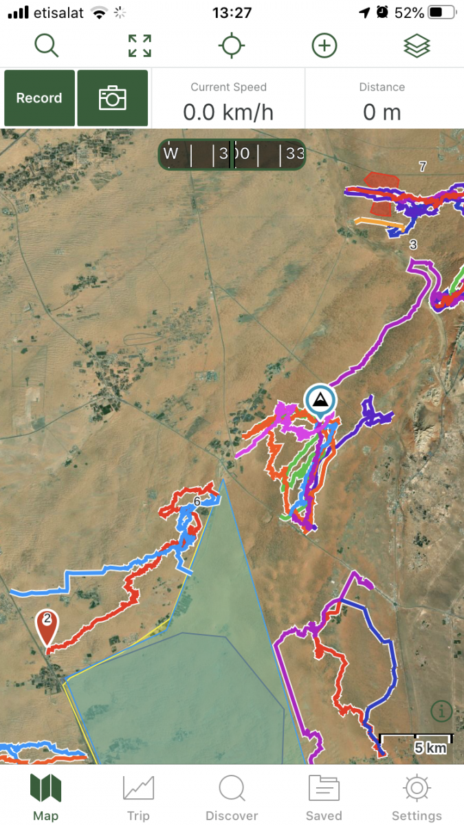
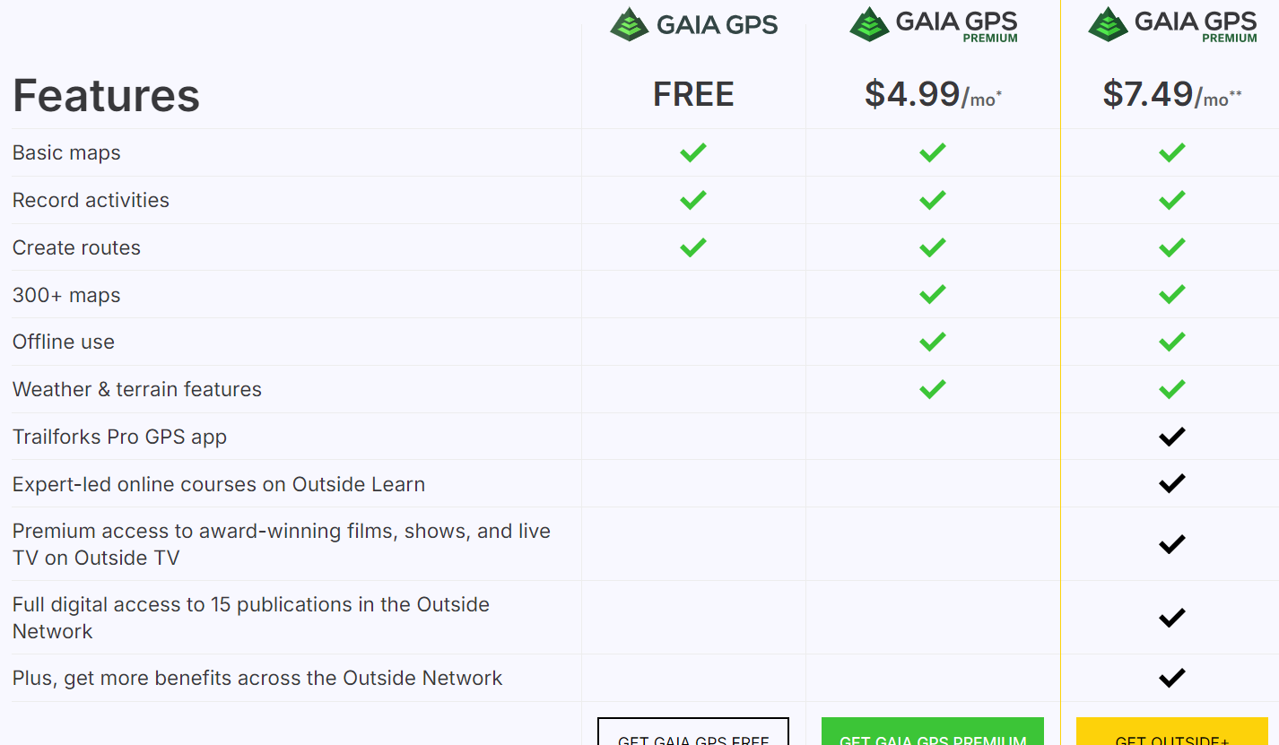
For many offroaders, navigation looks like a scary thing, and finding your way in the desert used to be a daunting task with old obsolete maps, navigation with sun or stars, and many other old tricks of crossing the deserts. Until 5-6 years ago, companies like TomTom and Garmin were ruling the world navigation software and hardware, until our phones became smarter and smarter, and nowadays there are tons of free or paid navigation software programs available which are tailored for hiking, off-roading, cycling, or other outdoor activities where you would like to record your tracks. In this post i will give some basic essential advice on how to get started with navigating by using GaiaGPS, which is an amazing app that allows you to: 1) Create routes at home via your desktop/tablet through the GaiaGPS website. 2) Use different types of maps like topographic maps, sattelite maps, to find your perfect route you'd like to explore. 3) Save and manage all your tracks, waypoints, areas. 4) Automatically sync all this data with the GaiaGPS Mobile App that is being used to record your track or follow the route you have created beforehand. 1) Registering for GaiaGPS account https://www.gaiagps.com/membership/ You can choose for a FREE account, which works fine for basic topographic and satellite maps, but will not allow to use them offline. The PREMIUM membership is recommended for around 60USD per year. The Outside+ subscription is useless as this is mostly for US based customers. Their Trailforks Pro App is very similar to Wikiloc. Once you have become a member, you can head over to Gaiagps.com, login with your account name, and have a look at the basic functionalities. I've posted a short video below that gives a small demo on how to use the GaiaGPS website functionalities. As you can see in the screen, there are many tracks i've recorded with my phone that remain saved in the website. You can remove these or hide them. The red zones i have marked are called "areas" where you can identify tricky areas that you would like to avoid. They will appear on your phone app as well so you can easily avoid them. Waypoints Waypoint, or pins, could be points of interest, landmarks, entry and exit points, or any place where you want to mark the location and save for later reference. They will appear as a "pin" on your map. You can assign a color to them as you like. This might be useful as you can categorize them. Next to the classic PIN icon, you can choose different other ones, like fences, skulls, forest, or anything that will help you in identifying the waypoint. Satellite Images Having crisp detail in the satellite images you are looking, is essential so you can create a route which focuses on the nice bigger dunes instead of the small technical or bushy areas. Gaia comes standard with the Mapbox "Sattelite with Labels" Imagery which is not bad, but the best one i have found so far is the ESRI Sattelite Imagery Map. Below you will find some information on how to add custom maps. The map called "WORLD IMAGERY" in the Premium version is the same as the ESRI Sattelite Imagery Map. Which phone ? Gaia GPS will work on any smartphone that has a decent GPS antenna built-in. In my case i purchased a separate dedicated Android phone which is mounted in my car that i solely use for navigation. This allows me to keep using my own phone as backup device. That dedicated phone has the offline maps downloaded on it, so i don't need cellphone coverage (no sim card). App functionality On an Iphone, this is how the app looks like. The buttons like "RECORD" and "PICTURE" are customizable, and by keeping your finger on it you can select something else you would like to see on the home page. The Magnifying Glass allows you to enter coordinates. You can copy them from within Google Maps. this button toggles between full screen or normal screen. The crosshair button is very important. Click on it once and it will appear green and bring you to your live location and follow you while keeping NORTH up. Click on it again and another logo appears, looking like two reversed triangles. This is the mode that keeps your live location but constantly rotates the map based on your direction. You can experiment with both modes to see what suits you best. I like to stick to the first mode because it allows me to see in which compass direction i am heading. The + Button contains all your other useful functionalities, like adding a waypoint, creating a route, download an offline map, or create an area. Once you hit the record button, the app will start recording your track. Once you finish, click again on it and select "Finish Track" It will then be saved. (and also appear on your GaiaGPS website once you have synced). On the bottom, you can see your trip details, open the list of saved tracks, or go to your settings. Note: In the settings you can put your units/distances in miles or kilometers (whatever you prefer). You can also enable or disable the autosync function, but better to keep it on. So as soon as you have Wifi/Internet on your phone it will automatically sync your tracks between the app and your GaiaGPS account (website). These things will take a bit of practice, and i can recommend you use your Gaia mobile app for a while on your daily commute and experiment a bit with the settings until you have tailored it to your own needs. Exporting Maps Most navigation software use .gpx or .kml files which you can import in Google Earth / Maps or any other navigation program. On the GaiaGPS website, and also on the app you can choose to "export" your track. It will create a .GPX file that you can share with fellow offroaders or import in the Relive app Adding Custom Maps Adding a TMS Map Source – Gaia GPS for the GaiaGps app users, the Google Maps like Satellite, Terrain, or Hybrid, are not standard built in, but can easily be added by using the GaiaGps website. This is the procedure to add for example Google Terrain. 1) While logged into Gaiagps.com, add a custom map source via TMS here: https://www.gaiagps.com/mapsource/add/ 2) Fill in this TMS URL to get Google Terrain: https://mt0.google.com/vt/lyrs=p&hl=en&x={x}&y={y}&z={z}&s=Ga 3) Give it the name "Google Terrain" 4) Set the Min and Max Zoom level on 4 and 19. 5) Click on "Add this Map Source" The next time you will login it will appear in your mobile app. Some other map links. To add them, follow the same steps as above: Google Maps: https://mt1.google.com/vt/lyrs=r&x={x}&y={y}&z={z} Google Satellite:https://www.google.cn/maps/vt?lyrs=s@189&gl=cn&x={x}&y={y}&z={z} Google Satellite Hybrid:https://mt1.google.com/vt/lyrs=y&x={x}&y={y}&z={z} Google Terrain:https://mt1.google.com/vt/lyrs=t&x={x}&y={y}&z={z} Google Roads:https://mt1.google.com/vt/lyrs=h&x={x}&y={y}&z={z} ESRI Sattelite Imagery:https://server.arcgisonline.com/ArcGIS/rest/services/World_Imagery/MapServer/tile/{z}/{y}/{x} Open Topo Maps: https://a.tile.opentopomap.org/{Z}/{X}/{Y}.png Others can be found here: Folder: / (arcgisonline.com) 15 Free Satellite Imagery Data Sources - GIS Geography


- 72 replies
-
- 41
-

-

-

-

-

-
Hi @jose Shanu welcome to your new extended offroad family ! The Prado will be your perfect companion for your offroad adventures. Please have a look at the briefing video in the drive topic as this will give you a massive headstart to learn offroading in the safest way. See you tomorrow !
-
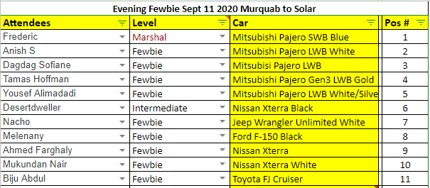
RSVP IS NOW CLOSED Another strong looking convoy, and with @Anish S in my second lead, and @Desert Dweller as my center forward, i am sure we will be able to make some good terrain. @Biju Abdul can take the sweeping duties and keep the convoy nicely together and moving. Starting from Murquab, there is a nice mix of technical dunes and long range dunes, but the tricky thing in this area is that the higher dunes are quite complex and at some point difficult to cross, as they run zig-zag without any pattern. That means this will be a drive where some focus is needed and an emphasis of giving each other enough space to build momentum and take you through. Anyways we are all here to learn and won't leave anyone behind, and i will try to find some nice play areas where we can do sidey's and some basic criss-crossing and ridge riding. See you guys tomorrow ! PS We will be using Carnity Channel 4 (446.08125 Mhz) tomorrow.
-
Hi @Biju Abdul i have added you to the RSVP. Kindly confirm if you can make it.
-
With my biggest fear being the yearly RTA inspection crew suddenly saying: "Where is your Catalytic Converter Sir, we cannot pass you if you don't have it" i would like to keep it in place. The few percents power savings are not worth it in my opinion.