Jump to content

Frederic

Members
  • Posts

    9,035
  • Joined

  • Last visited

  • Days Won

    451
  • Country

    Belgium
  • Carnity Points

    273 [ Donate ]

Everything posted by Frederic

  1. Thank you all for joining today ! Thanks to @Srikumar@DP1011@Rob Sand @Melenanywe had a fantastic support in this massive convoy ! Photo Gallery can be found here: Newbie - Scenic Trails of the Three Emirates - Sharjah - 13 Oct 2024 - Carnity.com See you all soon for more scenic adventures !
  2. RSVP IS NOW CLOSED @Ahmed Wagdy@jackie gomes@Andreas Riis@vinayakm@Jose Luis Campos@Hetal@Srikumar@Abhishek Chikara@Sam_@Arvindraj@rroker@Vijaya Kumar Doppa@Rob S@Gilberto@Sviatoslav@Maytham Mahroos@Frederic118@GeorgeFJ@Sumedh Krishna@DP1011@Rohit Deginal@Jon L@Zubail@Theo09@Zubair@Haneef Thayyil@Nathan@Mike M.@Melenany As you all can see this will probably be a convoy that will be driving in two emirates simultaneously Some pointers, please take note: 1. Upon arrival please park on the right hand side so the farm track remains clear for the farmers passing by. 2. Deflate to 14-15psi if you have HT tires, or 12psi if you have AT tires. 2. We will use Channel 2 - 446.031Mhz 3. Briefing will be rather short as we will be mostly driving on farm tracks. Main important thing is to keep a bit of distance in-between the cars and keep your radio on. Seniors and supporting members on the drive are @DP1011 aka Deepak with dark grey Rubicon Jeep, @Rob S with the Sandy coloured FJ Cruiser, @Srikumar with the green Jeep Cherokee XJ, @melenany in sweep with the green Ford F150 Pickup. Please try to arrive 10-15mins earlier so we can all leave on time. See you all tomorrow !
  3. That is very kind of you @Abhilash Kottakkal ! In the meantime i have now added everyone who is on their 1st drive of the weekend. Good morning @jackie gomes and welcome to Carnity Offroad Club ! Kindly revert on below request: First time with Carnity Off-road Club: Please share your vehicle details - Make, Model, Color, and Year. Do you have any prior off-road experience? If yes, pls share details. Confirm your vehicle has front and rear tow hooks/eyelets. Advise if you don’t have a programable radio and safety flag. MUST WATCH: NEWBIE VIDEO BRIEFING See you on Sunday ! Let me know if you have any questions.
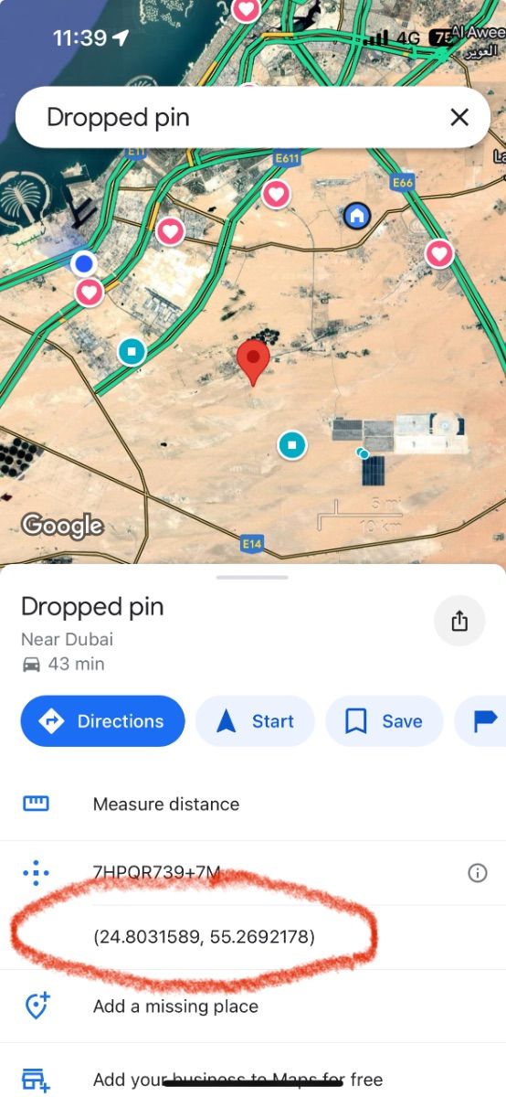
  4. I have a GPS riddle for you guys. This is the location where we are planning to take a break. Send me a screenshot of the place once you found the decimal gps coordinates: Latitude Riddle: -World pasta day is every year on the ….. of the month October. -How many days are in 131 years? Longitude Riddle: -An exoplanet located a mere 41 light years from Earth, where an atmosphere was found recently. -calculator upside down shows 1hE88. Good luck 😁
  5. Congrats @ALEX 0171 I guess it's true what they say: Greeks get it done faster 😆
  6. One word.... well actually two: RAM MOUNT I don't use an ipad in the car, for the simple reason my car is a bit cramped, and there's already other stuff mounted in there like a built-in radio, Gaiagps phone, Garmin device, and some other gadgets 😁
  7. Many of us have friends, or family members who venture into the UAE deserts or mountains during the pleasant winter season. Unfortunately, they sometimes end up getting stuck or find themselves in unsafe situations. As a club member you gradually become more experienced and would sometimes like to offer those essentials with your friends. Telling them to join us is a great tip but in reality, not everyone wants to become a seasoned weekly off-roader, or they have other priorities they need to attend for. We made this leaflet to share around amongst anyone you know, to help educate them about the essentials of off-roading so they are safe at all times. It is a single page so they can print it or keep it on the phone. We are providing a Landscape or Portrait version in PDF format. Please help us in sharing these leaflets to ensure a safe off-road season for all the people we know and love! Carnity Leaflet Landscape.pdf Carnity Leaflet Portrait.pdf
  8. Another example is my Garmin 66sr handheld device promises around 2m accuracy but this only works while hiking (moving slowly) and being outdoor. So not zooming by at 30kmh in a Jeep
  9. Good point @Anoop Nair I use two Garmin devices as well and they seem to be a slightly more accurate, but only marginal, and the main variations is the fact that your phone is inside the cabin of the vehicle. Once you exit the vehicle and give it a few seconds it will give a better accuracy. 10-15m accuracy should definitely work in most situations.
  10. Finding our way in the desert probably was never easier than it is today. All of us have a phone with GPS signal and with a simple click on Google Maps we can see where we exactly are in the desert. In below topic we will compare some of the most known GPS applications and devices. Of course there are probably hundreds of apps on the market, but we will focus on the apps often used by off-roaders and particularly in this part of the world (Middle East). It is important to divide GPS apps into different uses, based on the type of off-roader you are. 1. Record the track you have done with the club. Can be done with most GPS apps free of cost (GaiaGPS, Gurumaps, Alltrails, etc..). In the free apps you might be restricted to Topo maps only, not satellite imagery. Offline download of the maps will not be possible. 2. Find tracks uploaded by others and follow them. Once you have some off-road experience and you recorded some tracks, it might be interesting to find trails that others have posted or uploaded. The community approach of Wikiloc, Trailforks, or Alltrails is perfect for this. 3. Create your own maps, routes. This part is more for people who lead drives or want to create their own overlanding routes. It will be important to have access to good map layers like satellite imagery or topographic maps, or POI (points of interest) so you can trace a route of where you are planning to go. This kind of planning will need to be done on a laptop or computer. You can use Caltopo, GaiaGPS, or even Basecamp. Advantage of Basecamp is it's a standalone windows program that does not need an internet connection. Disadvantage is the limited amount of maps you can use (satellite imagery only possible if you have a Garmin device with Birdview license). I personally prefer Caltopo as my planning program and then export to my mobile app. Google Maps (Phone and Website) While Google Maps is good for basic use, it lacks recording possibilities, so it does not provide an option to record your tracks and re-visit them for later use. You can add some waypoints and save them in the application, but as most of this requires a data or wifi connection to work properly, Google Maps is not ideal for navigating in the desert. It allows for downloading some offline maps, but even this is a temporary function (30 days from what i could remember). The positive points of Google Maps are the fantastic satellite imagery, and the POI (points of interest) which allows you to find nearby gas stations, lodging, etc.. and also provides the well-known turn-to-turn guidance. I think most of us use Google Maps or Waze for daily navigation in the city and we cannot miss it anymore. Garmin GPS devices (standalone - Desktop Functionality through Garmin BaseCamp. Even before Google Maps arrived, Garmin was the king of GPS and navigation devices but has lost lots of market share with the advent of phones and apps. For that reason, they jumped into the world of fitness apps and smart fitness watches. Devices like the Garmin 276C, launched in 2004, are legendary for all kinds of offroad navigation (marine, aviation, 4x4), allowing overlanders to store thousands of tracks and waypoints, and the 276C was known for being big but super reliable. In 2016 Garmin relaunched a facelift model called the 276cx, but in the meantime there were other models like the Montana series, or the Overlander model that offered similar features but now included touch screen features, while the 276cx remained a push button model. Of course it depends on the type of use, as bikers and boats might prefer the simple push buttons over a touch screen that will act up when it gets wet. The main advantages of dedicated GPS devices like Garmin are the screen quality (much less glare), reliability, and in most cases also accuracy is slightly better than a phone. Furthermore, it allows you to keep your phone for other purposes like preserving your battery in case you need to take calls. Their devices can take a serious beating, are often waterproof, and remain the preferred choice for hikers and adventurers that don't want to rely on a flimsy phone. The Garmin devices are also still popular with people who go overlanding across different countries, as all the maps are stored in the memory so there is no need for a data connection. Rather than buying the maps from Garmin, most people head over to Opentopomap or Openstreetmaps to download free and regularly updated Topo and DEM maps. (Digital Elevation Terrain Model - offering shaded relief). Tip: The Shaded Relief layer functionality is brilliant to find the bigger dunes and bowls They also offer satellite imagery by means of the Birdview satellite Subscription which used to be quite expensive, but seems to be released now as a free option. At least on my devices it shows as "valid until 2038". Birdview is not as crisp as Google Maps but is definitely not bad. The main disadvantage is the user interfacing and complexity of use. Garmin devices mostly have an older classic style of user interface (except for maybe the overlander model), while apps on phones became much easier to use. Secondly, Garmin really struggles to club together the different devices over the years into a centralized platform. Sure, you can connect your device with a cable to Garmin Basecamp on your laptop and this works fine, but wireless transfer of a GPX track to your phone works via the apps Garmin Explore or Garmin Connect, depending on which model. And on some older models like the 276cx you can use the Connect app, but you cannot export the track to GPX into your phone. All of this is for novice users a steep learning curve, and on top of that the devices are not cheap. If you like to venture into different countries and you want to have a dedicated device that contains all your maps and waypoints, then Garmin could still be a good fit. But as you will see further below in the phone apps, there are similar options. (keeping a dedicated phone that has an app with offline maps downloaded onto them). Garmin Basecamp desktop software, however old it is, remains a fantastic piece of kit for planning trips. What might be confusing to new users is the different ways of how Garmin considers tracks or routes or activities. Creating a route will put marker flags along the way so you cannot consider this is being an actual track. You can however convert a route into a track to overcome the limitations of a route. An activity is a recording that was made, like a hike, or an offroad drive. All in all Garmins is quite confusing in this aspect in comparison with the GPS apps. Gaia GPS (Phone and Website) GaiaGPS is an app that runs on your iphone or Android, and has been the market leader for offroad navigation via apps. There are plenty of Youtube videos that explains the functionality, and most of us in the club are using it. I found it by coincidence in 2019 and was then still using MotionX, that got discontinued eventually so if shifted entirely to GaiaGPS. Pros: - Fantastic amount and quality of built-in maps. For example, the one called "Sattelite with labels" which enables you to find trails (dotted lines). This alone has helped me tremendously to create routes for longer drives (scenic / overlanding). You can also add custom maps like Google Hybrid, Terrain, or Maps by having a look in my above post "Gaia GPS for beginners". - Great user interface, easy to learn. - Planning a route via the website works great, with snap-on routing that works flawlessly. - Offline download of your maps on your phone. - All tracks and waypoints are saved and synced across your devices and your account in the cloud. - You can enable a layer called "Public Tracks" which allows you to see tracks uploaded by other users. Great function to find new tracks ! Cons: - Number of updates over the last year has reduced the reliability. A few times i was automatically logged out of my account on my standalone phone without any reason. This is unacceptable when being somewhere in a remote place. - Syncing is sometimes slow and buggy. - Folder and organizing of tracks is not great. It's also quite slow to manage hundreds of tracks and thousands of waypoints via the website interface. A standalone desktop program would be fantastic and probably much faster. - Price has been steadily increasing over the years since Outside+ has taken over the ownership. - Route planning for draft or different projects is difficult. Sometimes i like to create a complete route with different waypoints where i don't want to keep this for later use. With GaiaGPS you are essentially always working within the same map (unlike Caltopo). Caltopo (Phone and Website) CalTopo - A Backcountry Mapping and Navigation Essential I found Caltopo as there has been a lot of discussion in the Gaiagps and Reddit forums of several users (hikers and offroaders) that moved over to Caltopo. I decided in 2022 to give it a try and it became my main app to plan routes (via the website). The main reason is that it allows you to work on different maps. So for example when i want to create an overlanding route through UAE, i can create a map called "UAE" and put all my routing and waypoint in there. I save it as a separate project and that way it does not clog up my other maps. Quite differently from Gaiagps but i really like this functionality. Secondly, the website works super fast ( no java-style like Gaia website), and it allows for quickly deleting tracks or waypoints without running through different web pages. I all looks a bit more dated but you get speed in return It also allows to create custom map layers, for example you can use the Google Sattelite image with a different layer. Currently i have a layer of ESRI sattelite footage with an overlay of Google Maps. It also offers a fantastic Shaded Relief layer, like described in Garmin above as well. The mobile app however is not yet where it should be in my opinion. It works less intuitively in comparison with GaiaGPS. Icons are smaller, and even though there are similarities, GaiaGPS offers a better user interfacing in general. The general consensus with many hikers and offroaders is that they use Caltopo website for planning their trips, and then import it in Gaiagps mobile app while on the hike/road. I do this as well quite often. There are different subscription levels, but most go for the Pro version which goes for around 50USD per year (similar cost to Gaiagps). If you are a plot surveyor or professional hiker, then the most premium (100USD per year) will offer you a standalone desktop version with more complicated custom functionalities. One disadvantage i found is that due to copyrights, the mobile app allows for offline maps downloading, but only a selected few maps can be actually downloaded. This is a bit of a turnoff if you are planning to use it often abroad when you have no data. You can however download the sattelite imagery, but this one lacks the "labels" which Gaiagps offers in their "Sattelite with labels". Guru Maps (Phone) Guru Maps - OpenStreetMap Wiki After testing so many apps, i personally find GuruMaps as good or even better than GaiaGPS. What i personally like most is the smooth flowing map when you are driving. While other apps have a kind of a stutter effect whenever the maps is shifting, Gurumaps doesn't have this issue. Unfortunately there is no website, so you will need to do your routeplanning on Caltopo or GaiaGPS and then export your route into Gurumaps. The interface is very user friendly and simple. Within minutes i found myself using the maps without having to scratch my head on where i could start recording or browse through my collection. The tracks you record can have a multicolor scheme based on speed or elevation. This is a very nice feature. For 22.5USD per year this works great for novice users. Disadvantage is the limitations in offline maps: it does not allow you to download imagery, only street and topo maps. This is a big disadvantage in my opinion, but probably explains the lower subscription cost. With Guru Maps Pro you can however import custom maps in MBtiles format. I've been experimenting with QGIS desktop software and now i am running GuruMaps with a Google Hybrid imagery offline downloaded layer! All Trails (Phone and Website) Alltrails is available for 36USD per year and offers a very user-friendly interface. It offers a view into nearby hikes or trails posted by others, so it has a bigger social functionality. I have not used the website and route creation function yet, but i think Alltrails is definitely a good option to consider using. It also allows for offline map downloading, and plenty of people in our club use it as well for the ease of use. To me, the website looks similar to Wikiloc, which allows you to find uploaded trails done by others. It does however not offer route-planning. Wikiloc (Phone and Website) The main focus of Wikiloc is finding trails posted by others (via the website), and by using the mobile app you can follow those same trails. Perfect for hiking. Outside+, the company that owns GaiaGPS offers something similar with Trailforks App. For off-roaders it can be used as well but lacks many functionalities. In my opinion it's a great platform to share your tracks on or download some interesting tracks that others have posted. That is the only functionality i am currently using it for. BackTrackMaps (Phone and Website) Backtrack: Maps for Backcountry Adventures. Very interesting desktop functionality when it comes to planning routes, and very similar to GaiaGPS. Also free to use for most of its functionality (30USD/YEAR for the PRO version) and even includes Mapbox Sattelite Imagery. Unfortunately, the mobile app only allows for "backtracking" your planned gpx routes, and does not allow recording your actual track. If this feature would be there, it would take a lot of Gaiagps customers away 2025 Update: Backtrackmaps has included Recording functionality.
  11. until
    DRIVE DETAILS Level: Absolute Newbie, Newbie and above When: 13th Oct 2024, Sunday Meeting time: 7:00 AM - Sharp (Without any exceptions) Meeting Point: Batayeh Farm Track: https://goo.gl/maps/wVRWfBhKKidwhzCy5 Approximate finish time: 10:30 AM approx Type of Car: Any proper 4x4 with front and back tow hooks and 8-10 inches of ground clearance. What to bring along: Loads of water, snacks (for yourself), smiles, enthusiasm and willingness to learn. Mandatory off-road gears: Tire deflator, tire pressure gauge, compressor, walkie-talkie radio, off-road flag, shovel, first-aid kit and fire extinguisher.
  12. DRIVE DESCRIPTION This will be a gentle overlanding / desert drive throughout the various terrain Sharjah, Umm al Quwain, and RAK has to offer. Bring your camera and let's explore together ! We request every member that joins this drive to go through the below information and strictly follow these guidelines, etiquettes and responsibilities. MUST READ AND COMPLY Environmental Policy Offroad Flag Guideline Two Way Radio Guideline Off road Driving Etiquette's Emergency details for all off-roaders Off Road Driving - Roles & Responsibilities First time with Carnity Off-road Club: Please share your vehicle details - Make, Model, Color, and Year. Do you have any prior off-road experience? If yes, pls share details. Confirm your vehicle has front and rear tow hooks/eyelets. Advise if you don’t have a programable radio and safety flag. MUST WATCH: NEWBIE VIDEO BRIEFING DRIVE DETAILS Level: Absolute Newbie, Newbie and above When: 13 th Oct 2024, Sunday Meeting time: 7:00 AM - Sharp (Without any exceptions) Meeting Point: Batayeh Farm Track: https://goo.gl/maps/wVRWfBhKKidwhzCy5 Approximate finish time: 10:30 AM approx Type of Car: Any proper 4x4 with front and back tow hooks and 8-10 inches of ground clearance. What to bring along: Loads of water, snacks (for yourself), smiles, enthusiasm and willingness to learn. Mandatory off-road gears: Tire deflator, tire pressure gauge, compressor, walkie-talkie radio, off-road flag, shovel, first-aid kit and fire extinguisher. LIMITED SPOTS AVAILABLE This drive is limited to 12 cars only. If the RSVP is full, you can add your name to the waitlist, once anyone drops, you will be moved to the RSVP list. RSVP will close a day prior to preparing a convoy list. Latecomers will be returned back - Without any exceptions. Members without RSVP will be returned back - Without any exceptions. Please withdraw your RSVP, if you aren't joining, so your spot can be taken by others. Repeated no-show members after RSVP will have their account suspended for a month. PLEASE RSVP ON THE CALENDAR
×
×
  • Create New...

Important Information

Terms of use