
-
5.0 Stars ⭐⭐⭐⭐⭐ 628 Google Reviews


Looper
-
Posts
5,192 -
Joined
-
Last visited
-
Days Won
99 -
Country
India -
Carnity Points
89 [ Donate ]
Content Type
Profiles
Forums
Advice
STORE
Events
Gallery
Blogs
Everything posted by Looper
-
I bought a 4-way hose, but I don't use it. All things being equal it takes more time to set up the 4-way hose and to pack it back than a single hose. Plus, I have a bluetooth module and when a tire is full, I switch off the compressor (just a soft switch off) and change the hose from tire to tire - this gives the compressor a few mins to cool down. Having said that - I would encourage you to go ahead with the project, as it is worth doing for the experience irrespective of all other factors and wishing you all the best.
-

How to Merge Different GPX tracks to Create One Track
Looper replied to Looper's topic in Off-Road Club's Discussions
Looks like CalTopo also does the same thing that Gaia GPS does exports/imports a bunch of tracks as indiviudal objects and does not merge them as One Continuous Track. Today I had to merge 10 differnt tracks so I imported them and exported them back. But when I re-imported into CalTopo; it imported the combined file as ten different objects and not as a single object - was I doing something wrong? On a side note; I like the fact that CaTopo shows the individual track names on the map. It would be easy when viewing tracks on the maps. In Gaia I hate that I don't know what track I am looking at. -
Wishing you a very happy birthday Sri.
-
How to Merge Different GPX tracks to Create One Track
Looper replied to Looper's topic in Off-Road Club's Discussions
Updated Track Point data with following: The track point data is contained between <trkseg> and </trkseg>. Each track point is consist of Latitude (lat), Longitude (lon), Elevation (ele) and date and time of recording. Time is mentioned in the file is GPS time which is almost same as UTC. The latitude and longitude is described in Decimal Degrees. -
How to Merge Different GPX tracks to Create One Track
Looper replied to Looper's topic in Off-Road Club's Discussions
Gaia GPS does not combine tracks when exported as folder; it exports the tracks inside the folder and when imported, the folder with its individual tracks are put back again. Today has been full of tasks that failed successfully.
-
premindra rajaram has been promoted to Fewbie Plus level
Looper replied to Gaurav's topic in Off-Road Club's Announcements
Congratulations @premindra rajaram on your promotion! -
Jaro Tuzinsky has been promoted to Intermediate level
Looper replied to Gaurav's topic in Off-Road Club's Announcements
Congratulations @Jaro Tuzinsky on your promotion! -
Marketa Dobesova has been promoted to Fewbie level
Looper replied to Gaurav's topic in Off-Road Club's Announcements
Congratulations @Marketa Dobesova on your promotion m. -
How to Merge Different GPX tracks to Create One Track
Looper replied to Looper's topic in Off-Road Club's Discussions
I am an accountant by profession with MIS and Financial Reporting specialization. Excel is my bread and butter. While I use a little bit of VBA code in a few spreadsheets; I don't really understand how it does what it does. I am generally as amused as the next person who is in awe of my spreadsheets lol. But I do, however, use Chat GPT. to help me with some documents in the regular work (e.g. corporate secretarial work, drafting agreements etc.) and it does a fair job. It prepares the initial draft for me to build up on. -
How to Merge Different GPX tracks to Create One Track
Looper replied to Looper's topic in Off-Road Club's Discussions
I think if we put 2 tracks in Gaia in a folder an export even that will perhaps do the trick.
-
Disclaimer: I don't know how to code or what it means. I just recognize patterns and go from there. I was trying to merge a couple of tracks into one and in my research found the following that might be useful if anyone wants to try. GPX files that you have which are recordings of GPS tracks are basically *.xml files that you can open on Notepad app or any text editor on your computer. Some apps do a better job than Gaia in structuring the file. Gaia GPS is just a bunch of code dumped into a *.gpx file. Here I have tried to separate them for easy reference. There are 3 parts to the GPX file 1. Start: The initial header data such as how it was created, the name of the track, description if any, color of the track etc. <?xml version="1.0" ?> <gpx xmlns="http://www.topografix.com/GPX/1/1" creator="GaiaGPS" version="1.1" xmlns:xsi="http://www.w3.org/2001/XMLSchema-instance" xsi:schemaLocation="http://www.topografix.com/GPX/1/1 http://www.topografix.com/GPX/1/1/gpx.xsd"> <trk> <name> IM0148A, Al Quaa, Abu Dhabi - Gaurav Soni </name> <desc> this file is combined from Gaurav Soni recordings </desc> <extensions> <line xmlns="http://www.topografix.com/GPX/gpx_style/0/2"> <color> 00B2FF </color> </line> </extensions> <trkseg> <trkpt lat="23.477482" lon="55.217087"><ele>115.0</ele><time>2022-11-12T05:08:11Z</time></trkpt> <trkpt lat="23.477484" lon="55.217087"><ele>115.0</ele><time>2022-11-12T05:08:20Z</time></trkpt> 2. Track Point Data: for every second or so the Gaia or any other recording app will make an entry in to the record. The track point data is contained between <trkseg> and </trkseg>. Each track point is consist of Latitude (lat), Longitude (lon), Elevation (ele) and date and time of recording. Time is mentioned in the file is GPS time which is almost same as UTC. The latitude and longitude is described in Decimal Degrees. <trkpt lat="23.477482" lon="55.217087"><ele>115.0</ele><time>2022-11-12T05:08:11Z</time></trkpt> <trkpt lat="23.477484" lon="55.217087"><ele>115.0</ele><time>2022-11-12T05:08:20Z</time></trkpt> <trkpt lat="23.477482" lon="55.217091"><ele>115.0</ele><time>2022-11-12T05:08:21Z</time></trkpt> 3. End: Towards the end the file is closed <trkpt lat="23.40979" lon="55.358162"><ele>123.0</ele><time>2022-11-12T12:01:20Z</time></trkpt> <trkpt lat="23.409809" lon="55.358177"><ele>125.0</ele><time>2022-11-12T12:01:26Z</time></trkpt> </trkseg> </trk> </gpx> Note: I have kept 2 rows of Track Point data in both Start and End for referance only How to Combine: Say you have 3 tracks then export them to desktop in *.gpx files format. You have to keep the start point and track point data and delete the ending of the file that starts at </trkseg> copy the text into a new text file and save it with extension *.gpx For the middle track copy the Track Point Data. and paste it in the new file you do not need the start or end portions of this file. For the last track, copy the Track Point Data and End data, and now you can save the new file and import that to Gaia GPS to see a new combined file. It will be imported into a new folder in Gaia. My referance Files: Combined File (I even changed the color, name and description while creating the combined file on the desktop) Track1 Track2 PS: Personally, I wouldn't stop recording till the drive is completed, meh! that's just me.
-
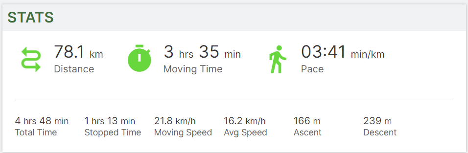
Drive Report: We started slightly later than usual, waiting for some later comers. I had planned to enter desert a bit down the line but couldn't sustain the temptation as soon as I could enter the dunes. The early entry meant that we met some very tall but soft dunes. We played on some long dunes in Faqaa area and then took one of many Sabkha to move towards Little Sweihan. After a brief drive though the large Sabkha, we entered some mildly technical areas and continued though some technical as well as smaller Sabkhas. Soon we reached Little Sweihan and started discovering all that it has to offer. At about 10 am we were ready to exit but were on the wrong side of Solar Park. The typical thing to do was to exit on E14, but I was not done yet. So, after a quick vote we decided to cross Little Sweihan towards Solar Park and exit. We completed the drive at the Innovation Center about 11:15 am. I could not have done what I did without the tremendous team I had on the convoy and excellent support from @GauravSoni and @Stumpy Paj @Gautam Bankaa: You did well for your first Fewbie drive on this kind of terrain. @Parliament: I know it was a successful drive, when I saw you after the drive. I hope you enjoyed it as much as I did. @Bravoecho: I guess it is finally time to upgrade the shoes. Just remember to rotate all tires this time. I would recommend you check out Michelin LTX AT2 tires. Have heard good feedback on them. @Adam James: I hope you had good practice after a long break, and you dusted off your off-road driving skills. I hope you had a good practice with the fabled A Trac system on your FJ. @Stumpy Paj: Thank you very much for being at the sweep and making sure we are all in good running order. Your quick instructions on the recoveries at the back were a boon. We did a decent kms in the desert, even excluding about 20-25 kms in the Sabkhas. Most of the stopped time came at the beginning of the drive where we had our first refusal and the pop-out. After that the other refusals were taken care of quite quickly.

-
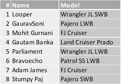
@Mohit Gurnani, @Gautam Banka, @Parliament, @Bravoecho, @Adam James, @Stumpy Paj and @GauravSoni Here's the plan for the morning. Meeting time: 6:00 AM Meeting Point: Faqa Fuel Station: Emarat- Grayteesah Radio Channel: 2 (446.031) Convoy Order:
-
Ah, the streak is finally broken. See you next time.
-
@Bravoecho, @Stumpy Paj, @rohit kumar, @Juan R, @Adam James, @Gautam Banka, @Mohit Gurnani, @Parliament and @Anoop Nair also @DP1011 and @GauravSoni Thank you very much for joining this drive. The plan of action will be start the drive at Faqaa and go towards Solar Park 🙄 obviously as the title of the drive post suggests - we will be playing in the Seif Dunes at Faqaa, after that we will cross a Sabkha to reach near what we call in our Club "Little Sweihan". We will find some manageable Barchanoid Dunes to play before we exit. Please double check your calendar, make good excuses if necessary if you have any commitments that you are trying to ignore and be ready. Please do confirm your availability by tomorrow afternoon to plan the convoy. We will publish the Convoy order Friday evening.
-
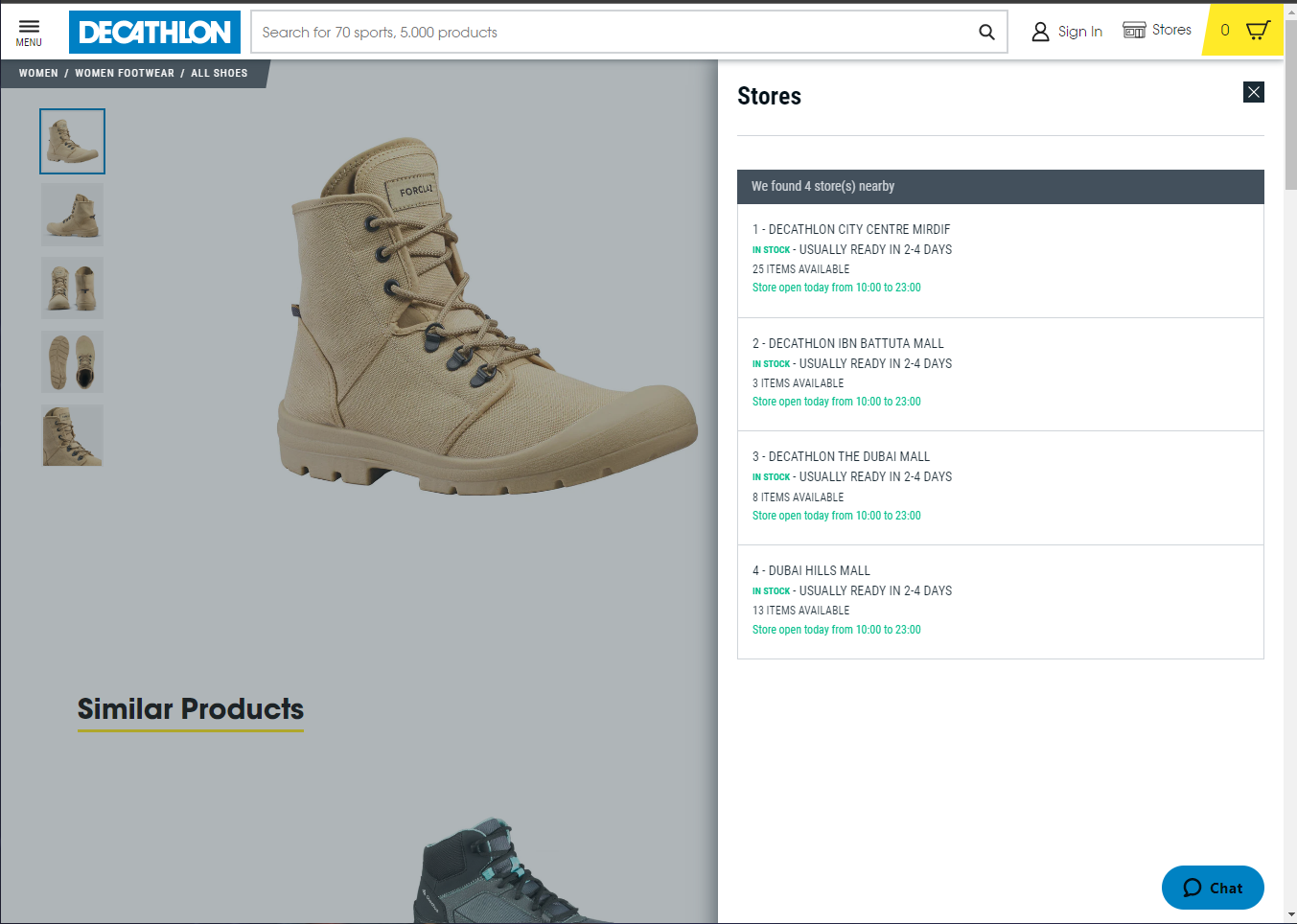
Decathlon may be the answer for you.

-
@Ahmad Nerat it’s a Fewbie Plus drive.
-
Yeah, I ware tactical sliders for FB+ and Intermediate drives since I expect to have a lot less shovelling and recoveries. For NB ans FB it’s tactical shoes only!
-
Gaia GPS For Beginners - 2024 Update
Looper replied to Frederic's topic in Off-Road Club's Discussions
We all have our own ways of organizing stuff, and something that works best for one might not work for another. As a compulsive data hoarder and list maker, I will never be able to bring myself to keep few tracks to delete others, I am OCD-d to keep everything and try to manage. Also, for the first 165 drives technically I never had any reason to go back and see where I was driving since all that I needed to do was to follow the lead. So, I would just move the file to the designated folder and hide them, not a single track on the Gaia! On the other hand, as seasoned off-roaders with way more experience than most of us reading a post about "Gaia GPS for Beginners"; we have a lot to learn from you. @Frederic! -
Gaia GPS For Beginners - 2024 Update
Looper replied to Frederic's topic in Off-Road Club's Discussions
Recently Gaia has been a regular topic of discussion, as I started to do partial leads. During these discussions, an issue that came up regularly is how the tracks become unmanageable and do not make any sense anymore, leading to users deleting their old tracks. I too found the same issue while I was still new, perhaps 10 to 15 drives old, and I was intermediate already! When I was driving in the same area there were multiple tracks in different colours, and nothing made sense. Since Fewbie level I have been organizing my recorded tracks and I want to share my housekeeping tricks in post in the hope that a few of you might find it helpful. 1. Start Early: If you start early to organise your drives and with a little bit of housekeeping from the start you can better manage the tracks in the future, and it does not become a big headache later. Even if you are not subscribed to the app, do record the tracks with the free version and save them. 2. Folders: Create folders for each level of drive, such as Newbie, Fewbie and so on. I have folders for other types of drives, e.g., drives with friends, wadi drives etc. After each drive while saving the track, immediately put the track in those folders while saving. Gaia also gives an option to add photos you took during the drive to attached. While I do it, I delete them (Profile>Photos) later as it leaves a bunch of waypoints that I don’t need. The photos seem to stay with the track even after deleting them. Saving tracks in folders makes it quite easy to hide/unhide (eye button in saved tab) a bunch of tracks at the same time. These days I hide all the tracks and keep the current plan visible. Any new drive you record will automatically be visible till you hide them. 3. Colour Coding: You can colour code all drives in a level with one colour. In my case I used the same colours that were used in my stats posts. I considered either colour coding or creating folders by Lead or Area instead of filing tracks by Level + color-coding them at the same time, because it seemed like duplication. But those options either did not add any value to me or the process made it more confusing for me. Your experience might vary. 4. Rename Tracks: Rename the track with the area you did the drive and the lead with who you drove in the title. I also put the participants' names in the notes section. This helps to find specific tracks by searching for them (use “Download guest list” in calendar to get text of all names). As a newbie lead, I go back to my most memorable drives from the past in an area to plan for the next drive. Some time I get to see a great track to drive and other times I take the convoy though a technical jungle; either way it is fun. -
You need what they call Tactical Shoes. The two most seen brands in the desert are from Decathlon and Antartica which is available from Amazon. You need a shoe which goes till ankle height and preferably made of canvas and/or leather and light as well, becase in the sand you don't want to wear those heavy work shoes like the ones from Cat. Also avoid sports shoes because they are made with breather able material, and they breathe in sand. Shoes meant for snow might work well, i guess - not sure though. In my experiance, Decathlon are well engineered, they go well with Decathlon Desert Pants. However, my pair developed holes on both the shoes near the small finger and started to fill up with sand. I once tried to attach some Duct Tape, and they looked cool for a total of 15 min before the tape fell off. So I was in the market, this time anything but Decathlon for a change, but I could not find anything good (I visited Outlet Mall on E66), so ended up buying the Antartica Brand from Amazon. PS: continuing my rant on Decathlon - when I washed pants in the washing machine and the hooks at the bottom shredded the pants near the ankle; lesson learnt - don't wash them in washing machine or wash them in delicate mode.
-
Cristian has been promoted to Fewbie level
Looper replied to Gaurav's topic in Off-Road Club's Announcements
Congratulations @Cristian on your promotion. Well done! -
Gautam Banka has been promoted to Fewbie level
Looper replied to Gaurav's topic in Off-Road Club's Announcements
Congratulations @Gautam Banka on your promotion. Well done! -
Pieter Pot has been promoted to Fewbie Plus level
Looper replied to Gaurav's topic in Off-Road Club's Announcements
Congratulations @Pieter Pot on your promotion. Now the fast pace starts… -
Benjamin has been promoted to Intermediate level
Looper replied to Gaurav's topic in Off-Road Club's Announcements
Congratulations @Benjamin on your promotion. You are an accomplished driver and I am sure you will enjoy this level a lot.