
Leaderboard


Popular Content
Showing content with the highest reputation on 08/15/2025 in all areas
-
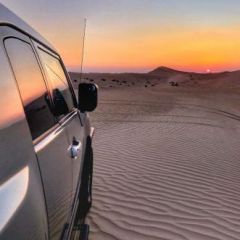
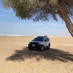
Please find the convoy numbering below. We will use Radio Channel 8: 446'181.5 @J-P L @Aringga @Sheho @Suneedh Wrangler @Ishak @khurramm @Danie @Ana @Gary F @Andrei S @Andrew John Melvill @ChrisW @Faouzi Gaurav Silver Pajero J-P L 2021 Suzuki Jimny 3 Door Grey Aringga 2022 Jeep Wrangler - 4 door - Snazzberry Red Faouzi 2025 Toyota Landcruiser Prado - Desert colour Ishak Pajero - LWB - Black/White Suneedh Mitsubishi Pajero - 3 Door - White khurramm Tahoe 2014 Danie 2024 Jeep Wrangler - 2door - Grey Gary F 2021 Jeep Gladiator Sandrunner White Ana 2019 Jeep wrangler -2 doors -Gray Andrew John Melvill 2020, Mitsubishi Pajero, 4 door, 3.8, white ChrisW Jeep JL - Earl Grey5 points
-
Dear Desertnauts ready to ball at the rhythm of Country Music, with a medium range drive (50 plus Km) that will take us from the Sweihan Ramlat area (big bowls and long-range dunes) through Sweihan's Pond, in a loop that will bring us back to Sweihan town. Medium level difficulties that we'll navigate at a pace that will depend mainly on the conditions of the sand, and how the slopes and ridges have transformed in a period of high winds such as this past few days. The well mixed convoy will line up as follow: @Giacomo in Second Lead @Bhaskaran Ramaswamy at #3 @Warbs at #4 @Myrko at #5 @Steve Farmer at #6 @ChrisW at Center @Shary at #8 @Kashx2 at #9 @Glenn W at #10 @Krinesh at #11 and @Aser in Sweep. See you tomorrow ready to go at 3:00 PM. Have a nice end of the week.2 points
-
Congratulations @J-P L for joining the Support Team with Carnity Offroad Club. Looking forward to seeing you grow further and helping others to learn the art of offroading in a safe environment. Please make sure your Carnity user profile is always updated with all the latest Emergency contact details. SUPPORT TEAM Pre-requisite 1) Minimum 10 any level "Carnity" drives are required after your Intermediate promotion to become eligible for the Support Team. Once you decide to join Team Carnity to excel further with your off-roading, people, and commanding skills, you will be extensively trained by the whole Team Carnity from Expert - Marshal - Crew at various stages by supporting different levels drives. Activities for Support Team Members Support different Marshals and Crew at Newbie level drives to demonstrate: Your ability and willingness to support new offroaders. Ability to gain control of commanding situations. And clear communication skills to help manage the convoy. Possible progress toward becoming an Advisor Once you have proved to be a regular Supporting Team member and have supported different trip leads on several Newbie and Fewbie drives, we will gather your periodic feedback. Based on this feedback and reviews you might receive an invitation to become a Carnity Advisor for further advancement within our community. You will also need to have completed a minimum of 5 Intermediate Level drives, and be a regular club member (minimum supporting 6 Newbie or Fewbie drives per quarter) to become eligible. Being invited to an Advisor role means we put our faith in you as a passionate club member who displays maturity and passion to carry your knowledge on to new off-roaders who are still progressing through the ranks.1 point
-
untilDrive Details Level: Fewbie and above Meeting time: 03:00 PM Meeting Point: https://maps.app.goo.gl/zHTU54Dek3K5hpZH7 Action Plan: First of a new series of drives dedicated to Country Music. Even though it is distinct American genre, it blends the folk music traditions of English, Scottish, and Irish immigrants with elements of African American blues, gospel, and other musical styles. Invariably, the stories told through Country music are based on everyone's most human and truest feelings - love, family, the rewards of one's work and the pleasures of one's leisure time - infused with fascination for being on the frontier of exploration and at the forefront of cultural innovation and exchange (what was once the feeling of living in America, and is now what feels like living in the UAE). Hence, each installment of this series will pick a song that will embody the spirit of the drive. This time it will be "Country Boy's World", by Jason Aldean. It tells the story of a "country boy" and his world, contrasting it with the experiences of someone unfamiliar with that lifestyle, a little bit "unfamiliar" like most of us must have felt faced for the first time with life in the UAE, and most of all facing its deserts and raw nature. What better area than Sweihan Ramlat to embody this feeling of frontier, wilderness and adventure.... What to bring along: Loads of water, snacks (for yourself), smiles, enthusiasm, and willingness to learn. Approximate finish time: 7:00 PM P.S. Only join if you have a compressor to inflate your tires after the drive.1 point
-
Great news @J-P L! Very pleased for you, and I am sure many of the club will benefit from your support and coaching along the way.1 point
-
Hi all, looking for your up-to-date take on off-road navigation apps. I’m considering moving away from Gaia (since the recent acquisition, the experience hasn’t matched my needs) and want to compare what’s new on the market with similar capabilities. Could you please share: App name & pricing (one-time vs subscription, any “pro” tiers) Key features: offline maps, satellite/terrain layers, GPX/KML import/export, waypoint & track management, accuracy/reliability, live sharing, 3D/contour/dune visibility, and device support. How it compares to Gaia: what’s better, what’s missing. Regional notes: map quality and reliability in UAE/GCC deserts. If you have screenshots or sample GPX files, even better. Thanks in advance for helping me pick a solid Gaia alternative!1 point
-
the Garmin Tread phone app is quite nice. I have been using this for route mapping, organising waypoints, and tagging routes etc. It is nice that the organisation is tag based instead of folders... so a waypoint or route can belong to multiple categories. the downside is cannot navigate using the app, so really it is my 'master collection of data' If only could navigate on the phone, I would give it 100% recommendation,. but then garmin would never sell a piece of hardware ever again. whilst i use the garmin hardware when driving, i usually select the tags i have planned to drive near (waypoints, routes etc) and 'share' to gaiagps on my phone as a backup.1 point
-
Thank you all for the update the RSVP list so for as follow: @topgear @nithish468 @Michael asir @Faraz94 @waqar @Mahmut @Sam Selim @Rodas today I have driven the proposed track . It’s doable for the level of the drive . It’s almost a straight line with not more that 50 to 100 meters of tight navigation to the tricky dunes around the straight line . In 80 percent especially the last third is entirely technical with unpredictable shapes and slopes . In the dark is different than the day light and strict adherence to the convoy rules is critical here . please check on your vehicle performance and your gear as per level . It’s a slow drive with full focus . Get enough rest before the drive to combat fatigue. it’s gonna be fun inshallah. Will see you all by 8 pm Saturday at the meeting point above mentioned in the topic . the convoy list will be done at RSVP closure tomorrow night or Saturday morning. Cheers Seidam1 point
-
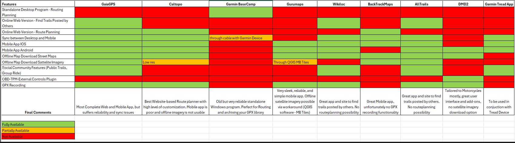
Good topic @Gaurav and good to revisit. Above i made an overview last year after doing lots of trials and tribulations. If your decision is to stick to smartphone (no Garmin devices), then these options i can recommend and i use myself: CALTOPO + Best website to organize and archive all your waypoints and tracks. (not the stupid folder type). This is my main program to store all my waypoints and tracks and never lost anything. + Phone application is fine to use which many custom map functionalities but there is a bit of learning curve. - Offline download of satellite maps is only low resolution due to copyrights. This is a pending issue. Using it online works totally fine. * Cost is 50USD/year if i remember correctly. GURUMAPS (app only, no website) + Very easy to install and use the phone app to navigate. + Free version allows for basic use. 40USD single purchase for life + Satellite imagery works fine if you have data on your phone. The maps are not super crisp but not bad at all. - No offline satellite imagery download option (only offline street and topo maps available). There is a workaround but it's quite complicated and i would not recommend (fetching MBtiles through Qgis).. There is also an app called GoatMaps, which have been launched by the original founders of GaiaGPS, but it lacks a lot of the functionalities and is not running stable with me. Then you have an app and website called Backtrackmaps, which surprised me with its ease to work with and the layout is similar to GaiaGPS. The only problem i see is that this is coming from a single owner / coder who made this, so i do not consider it as a professional platform. It has however lots of potential and might be worth testing. For any drive where i have data coverage, i use Caltopo and sometimes Gurumaps. For offline navigation i use my Garmin 276cx as it allows me to download Birdview satellite imagery beforehand which is quite nice. Takes some planning but i like the device as it's bulletproof and never let me down nor overheated.
 1 point
 -
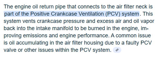
Sand in air filter neck near throttle body, the main reason is Positive Crankcase Ventilation (PCV) pipe, either clogged or worn out. Clean air filter neck + throttle body while changing PCV valve and breather pipe that goes into air filter neck. Also note, in some cars (like mine) there is an additional soft rubber sleeve over the pipe to prevent wetness and attract more sand seeping from that area.
 1 point
 -
Apologies Dr @M.Seidam, I will need to sign out from the drive due to a conflicting appointment on Saturday night. I will join you another time. Enjoy the drive on Saturday night.0 points

This leaderboard is set to Dubai/GMT+04:00