Popular Post Frederic Posted July 23, 2023 Popular Post Report Share Posted July 23, 2023 For many, Oman is tucked away somewhere in a corner of the Middle East, and even though you might have heard abouts its beauty, its hospitality, and its variety, it is quite large and takes a bit of preparation to explore. We decided to take a road trip over the last couple of weeks in Oman and it was no coincidence as to why we chose July. Every year, the Khareef (monsoon) blesses the Salalah region with clouds, rains, and turn the region into a green paradise. That includes daily temperatures around 26 degrees, and a lot of fog. As we were trying to escape the Dubai summer heat, we reckoned this was a great trip worth taking as we talked about it for years but kept postponing due to COVID and other issues. The main plan looks like this: Dubai to Nizwa: 420km to cover in Day One. Enjoy Nizwa old town, and Jebel Hatt/Akhdar. Nizwa to Salalah: 876km to cover in Day Two. 7 days exploration around entire Dhofar-Salalah region. (wadis, trails, beaches, etc..) Salalah to Duqm: 676km to cover on the 10th day, following coastal road and few stops in-between. Duqm to Sur: 518km on the 11th day, mostly along the coastal road, with planned stop at the Sugar Dunes. Sur to Dubai: 654 km on the 12th day, along Muscat, stopping on the occasional sinkhole but no wadis. (we explored those in 2019) Important Notes: 1. As we were traveling with one vehicle only, we were careful with off-roading and stuck to gatch tracks and existing trails as much as possible. 2. The drive from Nizwa to Salalah is long and boring (not scenic). You'll find petrol stations along the way where i recommend keeping your car always topped up. The temperature was +40 degrees, and you don't want your car to breakdown on this road so make sure it's serviced and fully inspected before embarking on this trip. 3. The main road that goes through Salalah is the Route 47, also called Sultan Qaboos Road. Although this is a stunning road and perhaps even one of the most beautiful roads in the world, the fog made the visibility in many places almost impossible to drive. Especially once the elevation exceeded 350m it became very difficult to drive, and the cows crossing the streets on the mountain villages did not help either. This also meant that some of the waypoints we wanted to visit closer towards the Yemen border took hours to reach and we even had to skip a couple of them. 4. Military checkpoints. The Dhofar region has a couple of military checkpoints. We did not face any issues but needed to carry our ID's at all time. 5. Rain, and lots of it. I was happy we got new tires installed two weeks before the trip, and the car underwent a full inspection as well. At times we could not even distinguish the color of the car anymore as it got so dirty from all the mud. Luckily carwashes were easy to find. 6. The Salalah region is predominantly Sunni, while the rest of Oman is mostly Ibadi. Throughout Oman we were advised to dress modestly and even then, we got a lot of curious stares and looks It felt like being back in Saudi in many cases (restaurants with family section, etc..). But overall, the people are very friendly and helpful. Further in this topic i will shortly describe the areas / waypoints we visited, with some photos to visualize the experience (although difficult). Stay tuned for more trip updates! 3 1 3 5 "Go as far as you can see; once you get there, you'll be able to see further." Link to comment Share on other sites More sharing options...
Frederic Posted July 23, 2023 Author Report Share Posted July 23, 2023 Trip Update: Date: 18 July 2023 Country: Oman Border crossing at Al-Ain Meyzad: https://goo.gl/maps/dfTBdaLyCXjAiZ1P6 Do not bring drones, two-way radios, alcohol, or any other illegal items! We sorted out our e-visas beforehand online (29A for sponsor and 29B for dependents), 5 OMR per person. The border official told me there’s a free visa for GCC residents somehow. Not sure if he meant online or on arrival. Crossing the border was very smooth and a matter of minutes only with a short visual check of the car. Make sure to get car insurance coverage for Oman and get the “orange card”’ from your insurer. This is just a piece of paper in Arabic that states your car is insured for Oman. Make sure the vehicle is under your name. I’ve seen an occasion where the guy was barred from entering because the car was under his wife’s name, and she was not with the group. Vehicle on car loan will need clearance from the bank I heard in the past. Not sure if this is true or still valid. Region: Nizwa - https://goo.gl/maps/EVo2Gx8e5fuGmots8 Known for: its fort and adjacent souk, a beautiful palm tree-lined city nearby the majestic Al Hajar mountains. Somehow it felt a bit cooler here than Dubai already. View from Jebel Hatt (2000m elevation): You can follow the tarmac road and climb all the way until this viewpoint: https://goo.gl/maps/NzuvpEsNyG6QX9rz6 If you fancy some decent off-roading trails, you can go from here all the way to Rustaq via Snake Canyon. https://goo.gl/maps/SXnWP6YEKvRWkrz19 We skipped this due to lack of time and the unpleasant weather (40+ degrees C). Courtyard of Al Bustan Inn, a cosy small hotel which we booked for one night: https://goo.gl/maps/PpKW2dpNavRXctSw5 5 4 "Go as far as you can see; once you get there, you'll be able to see further." Link to comment Share on other sites More sharing options...
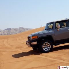
Popular Post Frederic Posted July 23, 2023 Author Popular Post Report Share Posted July 23, 2023 Trip Update: Date: 19-23 July 2023 Country: Oman Region: Salalah Places visited: Ain Khor Waterfall: https://maps.app.goo.gl/VhkiroCBds1aboVBA?g_st=ic Ain Athum Waterfall: https://goo.gl/maps/vRFZeT5bW3RALAzQA (nice but busy) Unknown Sinkhole: https://goo.gl/maps/eCxEbE7WMFtLzi2J8 (very nice) Tawi Attair Sinkhole: https://goo.gl/maps/oYu7mPJpbUQz4h7x6 (not that great due to limited visibility) Baobab Forest: https://goo.gl/maps/GHma7FRiF6fJNviL6 (nice little hike with manmade pool in the forest). Gravity Hill: https://goo.gl/maps/XPCmajKSpWNJaK4a8 (realized too late we were driving on the opposite side of the road). Ifalqoot Beach: https://goo.gl/maps/pyDuPvTHgvc5GuFs9 nice cliff with viewpoint (no beach). Shipwreck: https://goo.gl/maps/ECr9jsxYju41XFHH9 unfortunately the trail became inaccessible halfway due to the mud and big rocks. Wadi Darbat Hike and Wadi Trail (approaching from the North, as we tried from the regular entry from the south but there were long queues with too many visitors) start here: https://goo.gl/maps/KeEJDYrvWNXXVKx28 park here: https://goo.gl/maps/MnAjvjHvznTCvrM79 you can hike further down up to the viewpoint: https://goo.gl/maps/eoaLijXZQcdVE3gt5 unfortunately, there was no waterfall to be seen but the hike is really fun. Wadi Darbat Bottom Hike: https://goo.gl/maps/LFhn1gRFtUHJuZkU6 Leave the car at the parking and start the hike. Challenging at some places but real good fun ! Ain Razat: Cave, botanical garden, and picnic area. Nothing special and too busy: https://goo.gl/maps/6eXnjqo4yTZ7XXiv9 Mughsail Beach: https://goo.gl/maps/rQ5dBJFvpWf2z192A no swimming was allowed due to very rough sea. Mughsail blowholes: https://goo.gl/maps/SJTAKqRxrJXUWXDa9 (nice to visit but very busy). Mahsood hidden beach: https://goo.gl/maps/V9mCCsLU1FwhWjji7 (definitely recommended). Start from here and follow the wadi trail: https://goo.gl/maps/E7DgL75BkKjALY5A8 Fazayah Beach: https://goo.gl/maps/8EkfwGxVaM4XxAQm6 Start from here and follow the dirt track: https://goo.gl/maps/gFeLnckfS6iBZKcp6 Thumrait to Rakhyut Canyon Road: This was a stunning Route 66 experience which takes you to the middle of nowhere, apart from some tiny villages and beautiful out of this world canyons. There are a couple of military areas and checkpoints as this is not too far from the Yemen border so stay on the existing track. 50% of it is tarmac while the other 50% is a gatch track. Start from Thumrait and follow road 45 all the way down to Rakhyut. There are stunning beaches in that area. We were not able to reach them as it was getting late and extremely foggy. Absolutely amazing drive... Some photos: Up in the mountains: Baobab Forest: https://goo.gl/maps/GHma7FRiF6fJNviL6 In need of a car wash.... Along Road 47: https://goo.gl/maps/aGvtdXSrMW6YDWgH7 Mahsood Hidden Beach: https://goo.gl/maps/V9mCCsLU1FwhWjji7 Wadi Darbat Bottom Hike, the easy part: https://goo.gl/maps/LFhn1gRFtUHJuZkU6 7 2 3 "Go as far as you can see; once you get there, you'll be able to see further." Link to comment Share on other sites More sharing options...
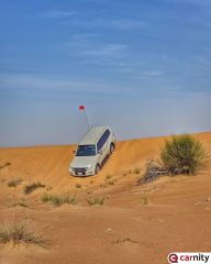
Popular Post Frederic Posted July 23, 2023 Author Popular Post Report Share Posted July 23, 2023 Some Photos Continued: Wadi Darbat Bottom: Becoming more challenging here: Wadi Darbat Hike and Wadi Trail: https://goo.gl/maps/MnAjvjHvznTCvrM79 Thumrait to Rakhyut Canyon Road: Unforgettable.... Fazayah Beach: https://goo.gl/maps/8EkfwGxVaM4XxAQm6 Ain Khor Waterfalls: 7 5 4 "Go as far as you can see; once you get there, you'll be able to see further." Link to comment Share on other sites More sharing options...
Varun Mehndiratta Posted July 23, 2023 Report Share Posted July 23, 2023 Hey @Frederic amazing post and good to see these pics. Planning a trip early august. Did you had a chance To camp around these places - or preferred all in Hotels? Was thinking of camping one of the nights, seems some restrictions in place in these areas. Any advice/suggestions. 4 Link to comment Share on other sites More sharing options...
Frederic Posted July 24, 2023 Author Report Share Posted July 24, 2023 8 hours ago, Varun Mehndiratta said: Hey @Frederic amazing post and good to see these pics. Planning a trip early august. Did you had a chance To camp around these places - or preferred all in Hotels? Was thinking of camping one of the nights, seems some restrictions in place in these areas. Any advice/suggestions. Thanks @Varun Mehndiratta! Camping is perfectly possible here in Salalah and even encouraged with many camping stuff for sale in the super markets. In our case we had booked a small villa for 7 days in Salalah and didn’t bring the camping gear along. After visiting the places we’ve seen so far I kinda wished we brought the stuff along. On the other hand it rains practically every night so that has to be taken into account. Our hiking boots needed two days to dry out so we had to alternate between wadi hiking and beaches. Lulu Hypermarket had nice camping stuff on sale, and we went to visit this store as well as we were passing by: https://goo.gl/maps/doh1pxuyTSKVh14E6 Small shop but some nice items. They even sell the Golden Camel compressors Overall I’d recommend taking some camping gear along and setting it up when you have the occasion and feel like camping, but there are plenty hotels for each budget in Salalah and we were happy taking that option as we spend a lot of time on the road as well during the day. 6 1 "Go as far as you can see; once you get there, you'll be able to see further." Link to comment Share on other sites More sharing options...
Looper Posted July 24, 2023 Report Share Posted July 24, 2023 Thanks @Frederic, it is an excellent and informative post. For lazy bums like me who can't plan anything it is a boon. 1 2 don't drive like its your last one. Link to comment Share on other sites More sharing options...
Pavel Pashkovskiy Posted July 24, 2023 Report Share Posted July 24, 2023 Amazing post. I need to plan it for next year definitely, alone or in the group. Will be happy to join this initiative. I've seen some posts in other clubs people getting together and organizing trip to Salalah. I am sure many of the Carnity members will be happy to be part of trip like that, regardless how much it will cost. 1 4 Link to comment Share on other sites More sharing options...
Gaurav Posted July 24, 2023 Report Share Posted July 24, 2023 Amazing and detailed trip report for letting poor ppl like us enjoy with words and pictures. Very well planned Fredy, ofc your level of planning is always meticulous, but I like the idea of the whole round trip to cover a long drive from both sides is very intelligent. I did it in a messed-up way due to unexpected changes. @Frederic and @Vanessa8580 enjoy your well-deserved break and drive safe. 2 2 Let's root for each other & watch each other grow. Link to comment Share on other sites More sharing options...
Bravoecho Posted July 24, 2023 Report Share Posted July 24, 2023 20 hours ago, Frederic said: For many, Oman is tucked away somewhere in a corner of the Middle East, and even though you might have heard abouts its beauty, its hospitality, and its variety, it is quite large and takes a bit of preparation to explore. We decided to take a road trip over the last couple of weeks in Oman and it was no coincidence as to why we chose July. Every year, the Khareef (monsoon) blesses the Salalah region with clouds, rains, and turn the region into a green paradise. That includes daily temperatures around 26 degrees, and a lot of fog. As we were trying to escape the Dubai summer heat, we reckoned this was a great trip worth taking as we talked about it for years but kept postponing due to COVID and other issues. The main plan looks like this: Dubai to Nizwa: 420km to cover in Day One. Enjoy Nizwa old town, and Jebel Hatt/Akhdar. Nizwa to Salalah: 876km to cover in Day Two. 7 days exploration around entire Dhofar-Salalah region. (wadis, trails, beaches, etc..) Salalah to Duqm: 676km to cover on the 10th day, following coastal road and few stops in-between. Duqm to Sur: 518km on the 11th day, mostly along the coastal road, with planned stop in Bar al Hikmann beach. Sur to Dubai: 654 km on the 12th day, along Muscat, stopping on the occasional sinkhole but no wadis. (we explored those in 2019) Important Notes: 1. As we were traveling with one vehicle only, we were careful with off-roading and stuck to gatch tracks and existing trails as much as possible. 2. The drive from Nizwa to Salalah is long and boring (not scenic). You'll find petrol stations along the way where i recommend keeping your car always topped up. The temperature was +40 degrees, and you don't want your car to breakdown on this road so make sure it's serviced and fully inspected before embarking on this trip. 3. The main road that goes through Salalah is the Route 47, also called Sultan Qaboos Road. Although this is a stunning road and perhaps even one of the most beautiful roads in the world, the fog made the visibility in many places almost impossible to drive. Especially once the elevation exceeded 350m it became very difficult to drive, and the cows crossing the streets on the mountain villages did not help either. This also meant that some of the waypoints we wanted to visit closer towards the Yemen border took hours to reach and we even had to skip a couple of them. 4. Military checkpoints. The Dhofar region has a couple of military checkpoints. We did not face any issues but needed to carry our ID's at all time. 5. Rain, and lots of it. I was happy we got new tires installed two weeks before the trip, and the car underwent a full inspection as well. At times we could not even distinguish the color of the car anymore as it got so dirty from all the mud. Luckily carwashes were easy to find. 6. The Salalah region is predominantly Sunni, while the rest of Oman is mostly Ibadi. Throughout Oman we were advised to dress modestly and even then, we got a lot of curious stares and looks It felt like being back in Saudi in many cases (restaurants with family section, etc..). But overall, the people are very friendly and helpful. Further in this topic i will shortly describe the areas / waypoints we visited, with some photos to visualize the experience (although difficult). Stay tuned for more trip updates! Looks like a great trip and I’m sure the Patrol did it with ease @Frederic 2 Link to comment Share on other sites More sharing options...


.thumb.jpg.faf264f698ded093f59df7be5597f9ce.jpg)


Recommended Posts
Create an account or sign in to comment
You need to be a member in order to leave a comment
Create an account
Sign up for a new account in our community. It's easy!
Register a new accountSign in
Already have an account? Sign in here.
Sign In Now